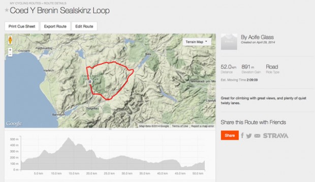
Long empty roads, beautiful views, challenging climbs and thrilling descents. It may not be quite the Alps but north Wales has a lot to offer the road cyclist, and we’ve found a great route around Coed y Brenin
To the mountain bikers out there, Coed y Brenin will be more familiar as the location of trail centre with a wide selection of routes to offer all level of cyclist, plus a shop, showers and toilets, cafe and bike shop. So essentially it’s got pretty much everything you need in one place.
These features also make it a great place to base yourself for a road ride, and we were introduced to a fun but challenging circular route by SealSkinz, producers of highly regarded waterproof cycling accessories. We also put their Waterproof Oversocks to the test, and we’re pleased to report toasty toes despite a blustery 4 hours of riding.
Route Overview
Turning right out of the trail centre car park, you join the main road (A470) for a steady uphill climb, which is perfect for getting your legs warmed up nicely. It is a main road, so expect fast traffic, but it’s also wide and straight so there’s plenty of space to allow safe overtaking.
Turn right again onto a smaller, quieter residential street, with a handful of houses around, and cycle past the Trawsfynydd Holiday Park. Here the climb starts to steepen, and be prepared for it to continue in this way for some time as you’re now climbing up high onto the moorland behind Coed y Brenin forest.
There are occasional downhills, flat sections or slightly-less-uphill sections that will give you a little respite, but cast your eye about as you ride because the views are stunning. If you’ve not ridden hills in a while you might be grateful of that third ring on your triple chainset. This part of the ride is also very exposed as you are out on open heathland, so if it’s windy (and it was when we tried it!) look out for gusts and make sure you have the right kit to protect yourself from the elements.
Once you reach the top, give yourself a well earned break and take a moment to enjoy the panorama of heathland with mountains off in the distance. Gather your breath, because you’ve now got a thrilling descent along twisting turning roads.
The view ahead is clear and you can see a long way ahead, which means you can safely spot potholes or any oncoming vehicles. We didn’t see any for hours! Vehicles that is; there were a few potholes but surprisingly not that many.
Next up come rolling hills as you gradually descend into the valley. You’re beginning to head into farmland at this point, so look out for gates across the road and cattle grids. There’s one gate in particular that’s hidden just around a corner after a descent, so be aware that they might sneak up on you.
We ended up stopping lots at this point, and not because of fatigue. The fields all around were full of spring lambs and daffodils; pretty much the definition of a Welsh spring.
As you continue to drop down overall you’ll find yourself dipping up and down through small valleys. Again this is farm territory, so make sure you close the gates after you and be aware of the livestock.
We shared one section of road with a small flock of sheep; riding slowly, carefully and keeping our distance, we passed them by no problem. Fears of being trampled by a sheep stampede were unfounded.
Reaching the valley floor once more, you’ll follow a selection of larger lanes and then join the main road (A494) for a long fast section that’s perfect for getting your legs going for a long spin.
Turning back off the main road to the right just past Rhydymain, there are more scenic quiet roads to enjoy through fields, and another climb up to the picturesque villiage of Llanfachreth. After here you’ll drop down along a forest road through towering pine trees to a small river valley, out the other side, and back down to the A470. We suggest stopping for a final breather before the climb back up to the trail centre here, and perhaps dipping your toes in the stream if it’s a warm summers day.
The rest of the route is a long steady climb along the main road, before turning right into the trail centre where you started.
We recommend finishing off with a cup of tea and a slice of cake, but if you fancy something more substantial to reward yourself with, the centre does great hot food too.
Summary
Best for: Great views and climbing practice.
Look out for: The roads are mostly in good condition, but look out for patches of loose gravel and the occasional errant sheep. Also watch out for gates across the road, and cattle grids.
Don’t forget: To shut the gates after you! And to bring plenty of water and the right gear as the first part of the ride is quite exposed.
Distance: 52 km (approx.)
Duration: 2hr 10min (fast) to 3hr 50min (intermediate). All times are approximate – allow extra time for gazing at the view!
Climbing: 891m
Profile:
Like this? You like these too:
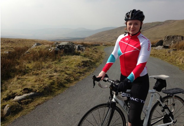
If you like the kit in the picture at the top, it’s by Pactimo. Here are our First Impressions of it.
Our reviewer loved the Pactimo Summit Raptor Bib Shorts.
Looking for a new bike? Check out our guide to 6 of the Best Women’s Road Bikes Over £1500

